
Файл:Kakhovka Reservoir Drys Up (MODIS).jpg

Исходный файл (2293 × 1772 пкс, размер файла: 488 Кб, MIME-тип: image/jpeg)
| Этот свободный медиафайл находится на Викискладе?, хранилище изображений и мультимедиа для использования во всех проектах Фонда Викимедиа. Cведения об этом файле показаны ниже. |
.jpg?uselang=ru)
Краткое описание
| Описание |
English: August 6, 2023 July 3, 2022
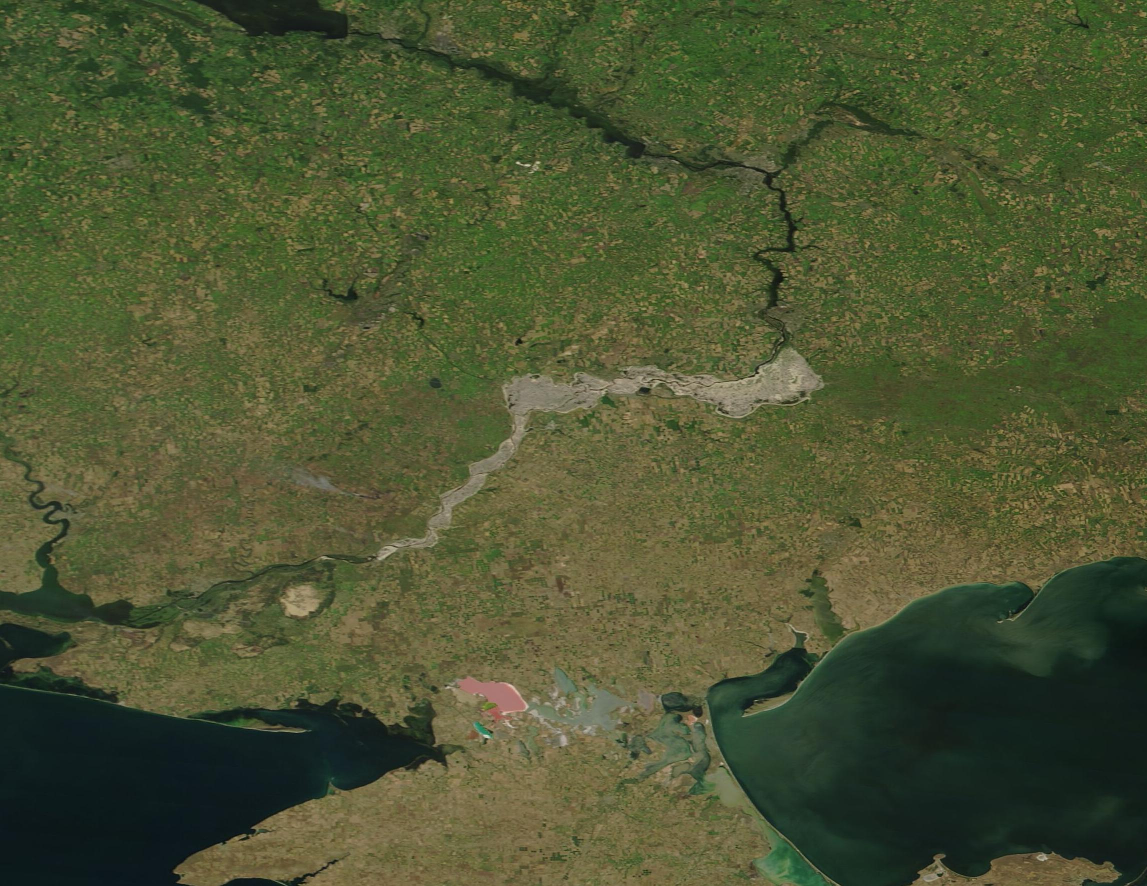
Kakhovka Reservoir was created in 1956 by construction of a 30-meter (98-foot)-high dam across the Dnipro River. The Nova Kakhovka Dam, measuring 2 kilometers (1.2 miles) in length, powered a hydroelectric plant and held water in a massive reservoir that was used for agriculture, drinking water, and provided cooling to the Zaporizhzhia nuclear plant. When the Kakhovka Dam was breached on June 6, 2023, water from the adjacent reservoir surged into the Dnipro River toward the city of Kherson and the Black Sea, causing severe flooding downstream. Floodwaters began to recede after a few weeks, but a slower-moving water problem unfolded as the reservoir dried up. Agriculture has been seriously damaged as the reservoir no longer provides water to irrigation canals. Concern also exists about the nuclear reactors, although the facility has a large cooling pond that was separate from the reservoir. So far, efforts to keep the cooling pond filled by pumping water into it from an inlet have been successful. On August 8, 2023, the Moderate Resolution Imaging Spectroradiometer (MODIS) on NASA’s Terra satellite acquired a true-color image of the Dnipro River and the mud-colored remnants of the Kakhovka Reservoir. Clicking on the dates below the image will allow an easy comparison between the August 8, 2023, image and one acquired of the same area by MODIS on Terra on July 3, 2022, when the Kakhovka Reservoir was full and functional. Nova Kakhovka, the town where the Dam was built, sits at the western-most edge of the former reservoir. The Dnipro passes Nova Kakhovka then flows into the Black Sea. The town of Zaporizhzhia and the nearby nuclear reactor are located on the Dnipro River just north of the eastern edge of the former reservoir. |
||
| Дата | Снято: 6 августа 2023 | ||
| Источник |
Kakhovka Reservoir Drys Up (direct link)
|
||
| Автор | MODIS Land Rapid Response Team, NASA GSFC |
| This media is a product of the Terra mission Credit and attribution belongs to the mission team, if not already specified in the "author" row |
Лицензирование
| Этот файл находится в общественном достоянии (англ. public domain), так как он был создан NASA (Национальным управлением по аэронавтике и исследованию космического пространства). Политика авторского права NASA гласит, что «Материал NASA не защищается авторским правом, если не указано иное». (См. Template:PD-USGov, страницу политики авторского права NASA или политику использования изображений JPL.) | ||
 |
Предупреждения:
|
История файла
Нажмите на дату/время, чтобы увидеть версию файла от того времени.
| Дата/время | Миниатюра | Размеры | Участник | Примечание | |
|---|---|---|---|---|---|
| текущий | 05:05, 14 августа 2023 | | 2293 × 1772 (488 Кб) | OptimusPrimeBot | #Spacemedia - Upload of http://modis.gsfc.nasa.gov/gallery/images/image08142023_250m.jpg via Commons:Spacemedia |
Использование файла
Следующая страница использует этот файл:
Глобальное использование файла
Данный файл используется в следующих вики:
- Использование в de.wikipedia.org
- Использование в en.wikipedia.org
- Использование в eu.wikipedia.org
- Использование в hu.wikipedia.org
- Использование в no.wikipedia.org
- Использование в www.wikidata.org
.jpg)